
of
of
of
As an administrative district of the Republic of Azerbaijan Gubadli was formed on March 14, 1933. It is located in the south-western part of the Minor Caucasus. There was one city (Gubadli), 93 villages in the district. The villages are: Ashaghi Jibikli, Khallava, Yukhari Jibikli, Balasoltanli, Garaimanli, Padar, Basharat, Armudlu, Deshdahat, Hat, Milanli, Chardagli, Eyin, Khalaj, Tarovlu, Chereli, Boyuneker, Saldash, Demirchiler, Poladli, Dondarli, Dileli, Muskenli, Mirler, Goyerjik, Aliguluushaghi, Farcan, Goyyal, Hartiz, Zor, Bakhtiyarli, Saray, Hal, Balligaya, Gazyan, Mamar, Mollali, Hemzeli, Chaytumas, Efendilər, Yusifbeyli, Khanlig, Khojahan, Gilijan, Tinli, Khochik, Mardanli, Garajalli, Garaghaj, Garakishiler, Garalar, Huseynushaghi, Kavdadig, Gayali, Abdalanli, Lepekheyranli, Mahmudlu, Mahruzlu, Muradxanli, Mughanli, Malikahmadli, Gundanli, Alagurshag, Davudlu Eyvazli, Gurjulu, Gadili, Mazra, Sariyatag, Tatar, Garagoyunlu, Giyasli, Teymur, Muskenli, Balahesenli, Khidirli, Ulashli, Altinja, Ebilje, Yukhari Khojamsagli, Ashaghi Khojamsagli, Mehrili, Yukhari Mollu, Ashaghi Mollu, Mollaburhan, Zilanli, Kurd Mahruzlu, Seleli, Novlu, Shigli, Hekeri, Gilfir, Seytas, Goyar Abbas, Khendek.
It is located in the south-west of the Azerbaijan Republic, in the south-east of the Karabakh plateau. It shares a 120-km border with Armenia, a 45-km border with Khojevend. Gubadli also borders on Lachin, Jabrayil, and Zangilan districts.
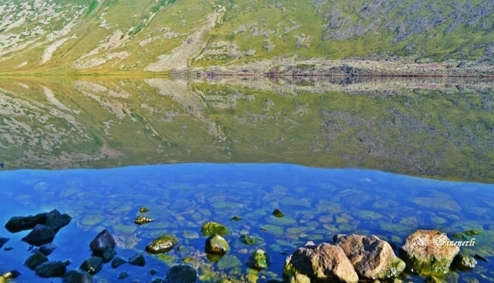
The nature of the Gubadli district is very beautiful. In 1969 state natural reserve was established there. There was a 13,160-ha national forestry fund in the district with different types of trees. Oak trees were the protector, hornbeam trees were the wealth, apple, pear, nut, medlar, cornel, hawthorn trees were the riches, mountain rivers, waterfalls, icy springs were the fame, black-eyed gazelles, partridges, pheasants, francolins, pigeons were the beauty of these forests. Two big mountain rivers flow through the district – the Hakari and Bargushad rivers. The Hakari River takes its beginning from Kalbajar district. Some mountain rivers join it until the Hakari flows into the Araz.
The Bargushad River takes its beginning from Erikli Mountain. The Bargushad gets its strength from the Delichay, Sheki, Sisiyan, Takhtakorpu, Dashli dere, Bakhtiyarli, and Agha Rivers that take their sources from mountain springs. The Bargushad River also flows into the Araz like the Hakari River. Both rivers interflow near the village Garalar of Gubadli district.
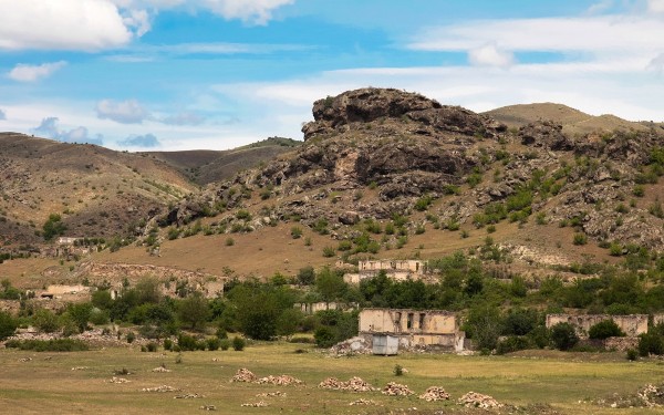
Though one part of the district is lowland, the main part is mountainous. Mountainous areas are covered with forests. Lifegiving springs in Hartiz and Senger Mountains of the district are considered to be a remedy.
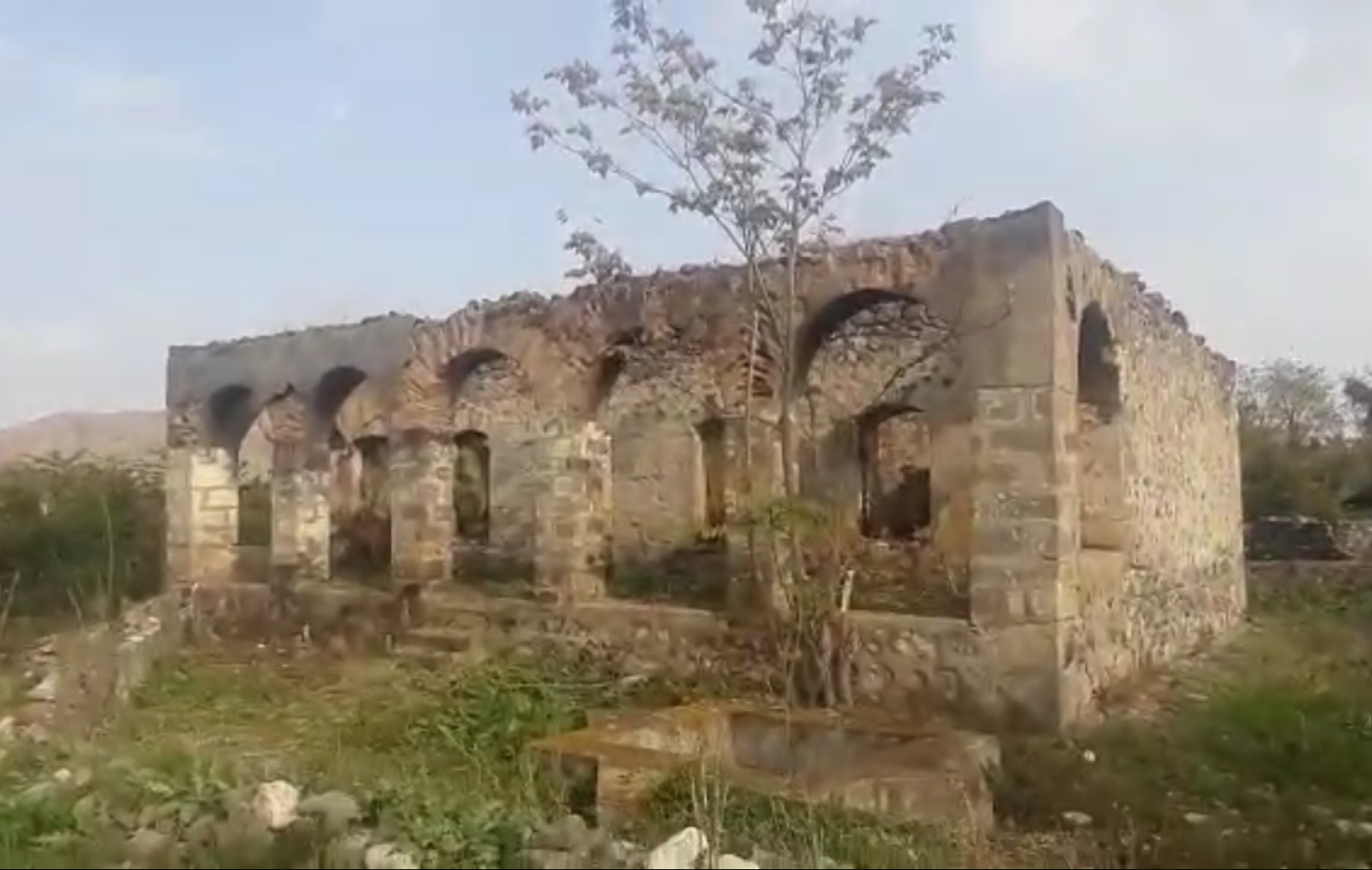
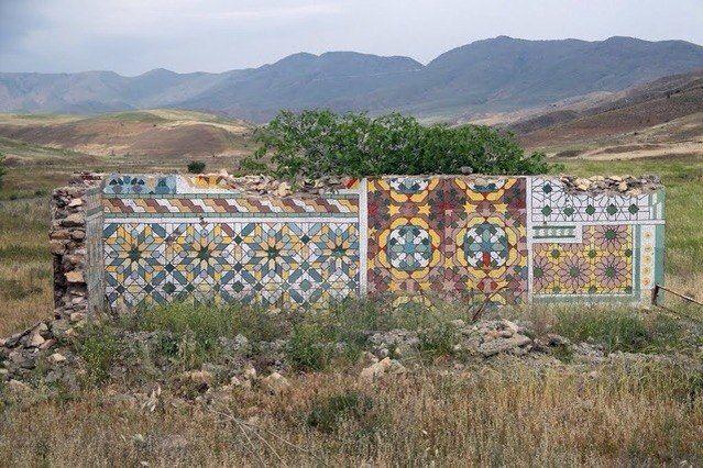
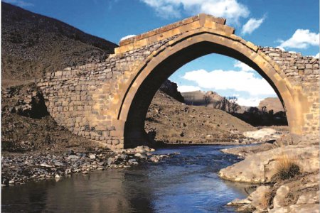
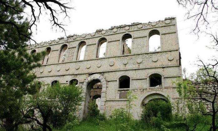
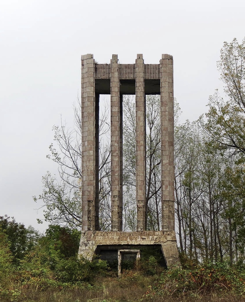
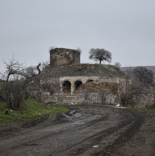
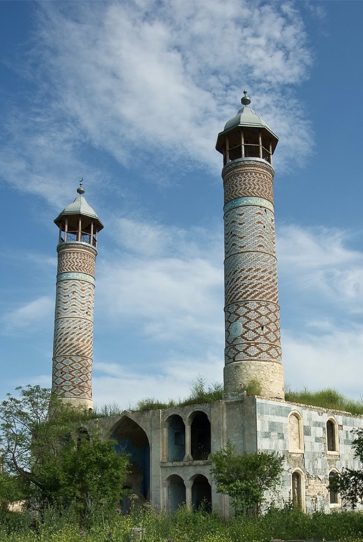
The cultural heritage of Gubadli included archeological monuments like a residential area of the Late Bronze-Early Iron Ages in the old part of Gubadli town, two castles of the Late Bronze-Early Iron Ages in Aliguluushaghi village, one more castle of the same period in Muradkhanli village, havens of the 4th century in the Aliguluushaghi, Balahasanli and Zor villages, one more of unknown age in Mahmudlu village, a 4th-century cave in the Gavur gorge and a 14th-century cemetery in the territory of Yazy flat on the one hand, and architectural monuments like the blue castle of the 5th century and Lalazar bridge of the 19th century in Aliguluushaghi village, the 13th-14th century tombs in Damirchilar village and the 18th-century tomb in Gurjulu village on the other. Moreover, as the territory of Gubadli, like Kalbajar and Lachin, was part of Caucasian Albania, it also had Albanian temples in the Basharat, Mazra, and Yukhary Jibikli villages. However, of the architectural monuments of Gubadli, the tombs were the most remarkable, especially the octagonal Albanian temple, Basharat village tombs, which came to the fore of the memorial architecture in the 12th century. The 13th-14th century tombs in Damirchilar village were examples of these.
The basis of the economy of the district is agriculture comprising grain growing, vine-growing, cultivation of tobacco, cattle-breeding, silkworm breeding. Industrial enterprises comprise dairy, vine processing plants, sewing factories. There was an unused agate deposit in Gubadli. There was a marble resource there as well.
Gubadli and its surrounding villages were included in the administrative territory of Nagorno-Karabakh in the XVIII century. Later, Gubadli, which was the composition of the Zangazur province, was included in Zangazur in 1868 after the establishment of the Yelizavetpol province.
Gubadli city is situated in the south-east of Karabakh plateau, on the bank of the Bazarchay River. 62 offices and enterprises were operating in the city. There was one asphalt plant, an incubator-poultry farm, stone quarry, technical supply department, clothes factory, a branch of Azerbaijan “Neftqazavtomat” experimental plant, and other industrial enterprises there.
In the Gubadli district, there were 21 general secondary schools, including 26 eight-year schools, 15 primary schools, 1 part-time school. Every year 300 students gained various professions at technical vocational school № 126 in the village of Khanlig.
Four hospitals with 685 beds, 33 medical centers were functioning in Gubadli. 111 cultural-educational institutions, 60 libraries, 10 cultural centers, 28 libraries, 6 auto-clubs, 23 film projectors served people in the district. 125 trade, 96 public-caterings, 25 domestic service enterprises functioned in Gubadli. There were 21 communication facilities in the district.
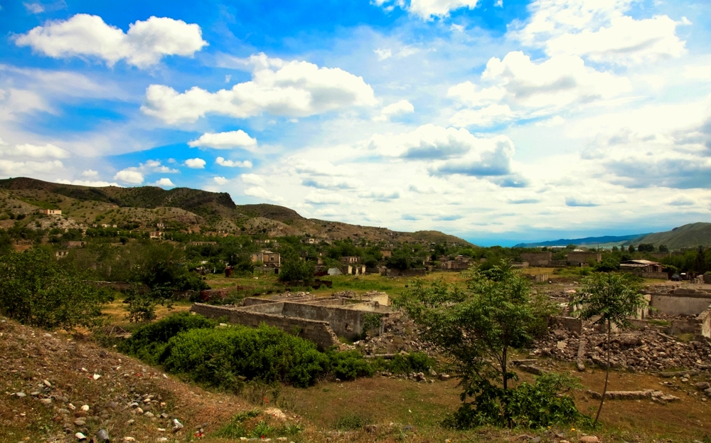
Gubadli district was occupied by armed forces of Armenia on August 31, 1993. Before the occupation tens of new public and residential buildings, gardens, avenues, squares, and bridges had been built; roads had been constructed in the villages and settlements. There was a secondary school for 1176 students in the settlement, a 422-students school for each of the villages Chapali, Dondarli, Mahruzlu, a 325-students school in Muradkhanli village, in Balasoltanli, Chardakhli and Garajalli villages a 192-students school for each, in Gayali village a secondary school for 216 students, a 192-seats school for each of the villages Demirchiler, Khandek, a 164-seats eight-year school in Garakishiler, Tarovlu, Ashaghi Khojasamli villages for each, primary schools in Mardanli, Padar, Giyasli, Abdalanli, Marlar villages. All these schools had been constructed before the occupation.
A new modern hospital, ATS, trade center, department store, supermarkets, bazaar, hotel, a bookstore in the city centre, a clinic in Mahruzlu village, out-patient’s clinic in the village of Garalar, library buildings in Khojic Ishigli, Dileli and Muskanlı villages had also been constructed before the occupation.
On October 25, 2020, the Glorious Army of Azerbaijan ended the 27-year Armenian occupation of the city of Gubadli.


Qaragol Interrepublics State Reserve was set up with the decision of the Council of Ministers dated November17, 1987. Garagol State …
The idea of establishing Aghdam Bread Museum, which is considered to be the second in the world after the Zurich …
The Khurshudbanu Natavan’s House is a historical and architectural monument of the 18th century located in the city of Shusha. …
Museum Mausoleum Complex of Molla Panah Vagif is located in Shusha, Azerbaijan. It was built in honor of Molla Panah …
Garghabazar Caravanserai was built in 1681 at the hillside, in the center of Garghabazar village of Fuzuli district, 8 km …
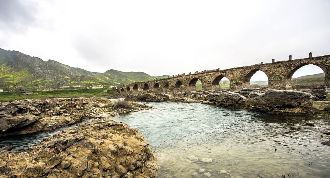
The Bridge belongs to the Arran architecture school. The first written source that mentioned the 15-arched Khudafarin Bridge belongs to …
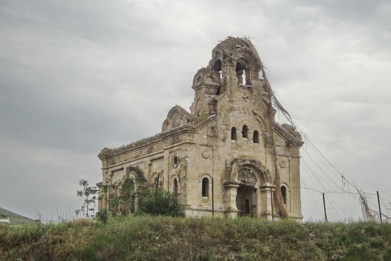
Armenia’s vandalism in Nagorno-Karabakh and seven surrounding regions affected not only the historical, cultural, and religious heritage of Islam but …

Jabrayil History-Ethnography Museum has been operating since 1953. Archaeological and ethnographic materials belonging to the history of the region, textiles, …

Khudavang, or Dedeveng, Monastery Complex is located in the Vang village of Kalbajar District, on the left bank of Tartar …
“The 19th century Aghdam Juma Mosque is perhaps the only structure that has withstood the years of neglect since the …